


The Environment Agency has issued a flood warning for parts of England amid concerns that affected areas could see more than a month’s worth of rain falling on Monday.
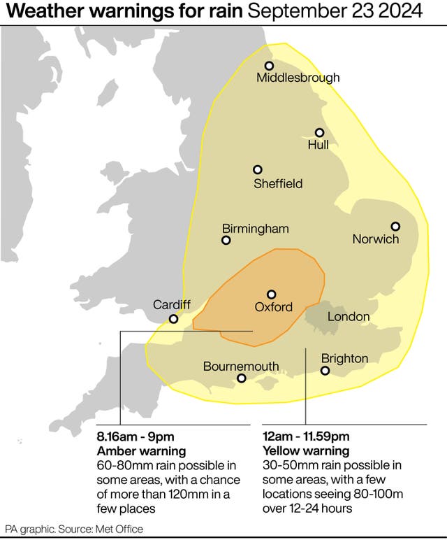
Rain warnings were in place all weekend with a fresh yellow alert coming into effect at midnight to last all of Monday, covering parts of Wales, much of the south of England, the Midlands and into north-west England and Yorkshire.
An amber warning came into force at 5am and will last until 11.59pm.
It initially covered Worcester, Birmingham, Nottingham and Hull but an update from the Met Office said the warning area had shifted further south and southwest. This includes Oxfordshire, Gloucestershire and Buckinghamshire.
Some affected areas could see 100 to 120mm of rain on Monday, and forecasters warned there may be more warnings in the week ahead.
Environment Agency flood duty manager Sarah Cook said “persistent heavy rain and thunderstorms” could lead to some property flooding and travel disruption.
She said: “Persistent heavy rain and thunderstorms could lead to significant surface water flooding on Monday across parts of England.
“The impacts could include localised flooding in urban areas and fast-responding catchments, including some property flooding as well as travel disruption. The risk from river flooding remains low.
“Environment Agency teams are out on the ground and ready to support local authorities in responding to surface water flooding.
Persistent heavy rain and thunderstorms across England tonight and Monday may cause surface water #flooding and travel disruption.
Plan ahead and sign up for flood warnings: https://t.co/P5d6Axp8Vq pic.twitter.com/BO1GCUjxqw
— Environment Agency (@EnvAgency) September 22, 2024
“We urge people to plan their journeys carefully, follow the advice of local emergency services on the roads and not to drive through flood water – it is often deeper than it looks and just 30cm of flowing water is enough to float your car.
“People should check their flood risk, sign up for free flood warnings and keep up to date with the latest situation as well as following @EnvAgency on X, formerly Twitter, for the latest flood updates.”
Met Office meteorologist Jonathan Vautrey previously told the PA news agency that Herefordshire, Gloucestershire and up towards the Wash and the Humber could see over a month’s worth of rain falling on Monday.

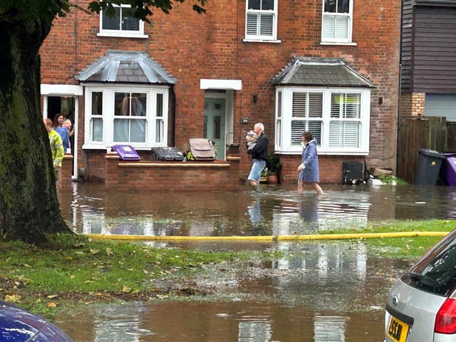
Heavy rainfall overnight has seen areas in Bedfordshire already submerged, with police confirming a number of road closures including Dunstable High Street. Footage shared on social media showed cars battling high water around the Saracen’s Head pub.
Central Bedfordshire Council said flooding had also hit Flitwick, Cranfield and Marston Moretaine.
As of 7.40am, 13 flood warnings – meaning flooding is expected – were issued for England by the Environment Agency.
Areas affected by the flood warnings include Atherstone in Warwickshire, Leighton Buzzard and Luton in Bedfordshire and parts of London including Wimbledon and South Ruislip.
AFC Wimbledon and Newcastle’s Carabao Cup third-round meeting on Tuesday has been called off due to “extensive overnight flooding” at the Cherry Red Records Stadium.
The Dons’ stadium in London is now closed as a result, with a rescheduled date for the tie yet to be confirmed.
A statement on Wimbledon’s official website read: “We regret to inform supporters that due to extensive overnight flooding of the River Wandle and surrounding areas, including at our Cherry Red Records Stadium, Tuesday night’s Carabao Cup third-round fixture against Newcastle United has been postponed.
“More information will follow in due course regarding fixture rearrangement.
“The stadium is closed until further notice.”


Comments: Our rules
We want our comments to be a lively and valuable part of our community - a place where readers can debate and engage with the most important local issues. The ability to comment on our stories is a privilege, not a right, however, and that privilege may be withdrawn if it is abused or misused.
Please report any comments that break our rules.
Read the rules hereLast Updated:
Report this comment Cancel